
Anúncios
Severe weather events like storms and hurricanes can strike with little warning, turning ordinary days into life-threatening emergencies that demand immediate action and preparation.


The advancement of mobile technology has revolutionized how we monitor and respond to dangerous weather conditions.
Anúncios
Storm and hurricane prediction apps now place sophisticated meteorological tools directly in our pockets, offering real-time alerts, detailed radar imagery, and life-saving forecasts that were once available only to professional meteorologists.
Whether you live in a hurricane-prone coastal region or simply want to stay informed about approaching storms, understanding how these applications work and which features matter most can make the difference between being caught off guard and staying safely prepared.
Anúncios
Let’s explore the essential aspects of storm and hurricane prediction apps that everyone should know about. ⛈️
Why Storm Prediction Apps Are Essential for Modern Safety
Gone are the days when we relied solely on television weather reports or emergency sirens. Today’s weather apps provide hyper-local forecasting that can pinpoint storm activity down to your specific neighborhood, giving you precious extra minutes or hours to prepare.
The National Hurricane Center reports that timely warnings have significantly reduced hurricane-related fatalities over the past decades. Much of this improvement comes from better communication technology, including smartphone applications that deliver instant notifications directly to users in threatened areas.
These apps aggregate data from multiple sources including satellite imagery, ground-based radar stations, ocean buoys, and weather balloons. The result is a comprehensive picture of developing weather systems that updates continuously as conditions change.
Key Features to Look for in a Storm Tracking Application 🔍
Not all weather apps are created equal when it comes to severe storm tracking. The most effective applications share several critical features that set them apart from basic weather services.
Real-Time Radar and Satellite Imagery
High-resolution radar displays allow you to see exactly where precipitation is falling and how storm systems are moving. The best apps offer multiple radar layers, including base reflectivity (showing precipitation intensity), velocity (indicating rotation that might produce tornadoes), and composite views that combine multiple elevation scans.
Satellite imagery provides the broader context, showing cloud formations, storm structure, and system development over large geographic areas. Infrared satellite views are particularly valuable for nighttime monitoring when visible light imagery isn’t available.
Hurricane Cone Projections and Track History
When tropical systems develop, dedicated hurricane tracking features become invaluable. The familiar “cone of uncertainty” shows the probable path of a hurricane’s center, while track history reveals where the storm has already traveled and how it has intensified or weakened.
Advanced apps display multiple forecast models simultaneously, allowing you to see where different meteorological algorithms predict the storm will go. This transparency helps you understand the range of possible outcomes rather than relying on a single projection.
Customizable Alert Systems
Push notifications can literally save lives during rapidly developing weather emergencies. Look for apps that allow you to set custom alert thresholds for your specific location and concerns—whether that’s hurricane warnings, severe thunderstorm alerts, tornado watches, or flood advisories.
The most sophisticated systems use geo-fencing technology to automatically adjust alerts based on your current location, perfect for travelers who need protection wherever they go.

Understanding Hurricane Categories and What They Mean
The Saffir-Simpson Hurricane Wind Scale classifies hurricanes from Category 1 through Category 5 based on sustained wind speeds. Understanding these categories helps you interpret app warnings and make appropriate preparation decisions.
| Category | Wind Speed | Expected Damage |
|---|---|---|
| Category 1 | 74-95 mph | Some damage to structures; power outages possible |
| Category 2 | 96-110 mph | Extensive damage; near-total power loss for days or weeks |
| Category 3 | 111-129 mph | Devastating damage; electricity and water unavailable |
| Category 4 | 130-156 mph | Catastrophic damage; most of area uninhabitable for weeks |
| Category 5 | 157+ mph | Complete roof failures; total residential destruction possible |
Your storm tracking app should clearly display the current and projected intensity of any approaching hurricane, helping you understand the urgency of evacuation orders or shelter-in-place recommendations.
How Meteorological Data Gets to Your Phone 📱
The journey of weather data from observation to your smartphone screen involves an impressive coordination of technology and expertise. Weather satellites orbiting Earth continuously photograph cloud systems and measure atmospheric temperatures, while Doppler radar stations scan the skies in 360-degree sweeps every few minutes.
Ocean buoys equipped with sensors transmit data about sea surface temperatures, wave heights, and atmospheric pressure—critical information for predicting hurricane formation and intensification. Weather balloons launched twice daily from hundreds of locations worldwide measure temperature, humidity, and wind conditions throughout the vertical atmosphere.
All this raw data feeds into powerful supercomputers running complex numerical weather prediction models. These models simulate atmospheric physics to forecast how weather systems will evolve over hours and days. The processed forecasts then flow through various distribution channels to reach weather app servers, which format the information for display on your device.
Popular Storm Prediction Apps Worth Downloading 🌪️
Several applications have earned reputations as reliable storm tracking tools, each with unique strengths that appeal to different user needs.
Windy: Visual Excellence and Model Variety
Windy stands out for its stunning visual presentation and comprehensive model selection. The app displays wind patterns as animated flow maps, making it easy to visualize how hurricanes and storms are moving and rotating. Users can toggle between multiple forecast models including GFS, ECMWF, and ICON, comparing their predictions side by side.
The interface feels almost playful despite presenting serious meteorological data, with smooth animations and intuitive touch controls for zooming and panning across global weather patterns. Beyond storms, Windy excels at displaying other parameters like wave heights, air quality, and temperature gradients.
Weather Underground: Hyper-Local Observations
Weather Underground leverages a network of personal weather stations maintained by enthusiasts and professionals. This crowdsourced approach provides incredibly detailed local observations that supplement official weather service data, particularly valuable for monitoring rapidly changing conditions during storm events.
The app’s storm tracking features include detailed hurricane information, severe weather alerts, and an interactive radar with future projection capabilities showing where precipitation will likely move in the next few hours.
MyRadar: Simplicity and Speed
For users who prefer streamlined interfaces, MyRadar delivers essential information without overwhelming complexity. The app launches directly to an animated radar view centered on your location, with storm tracks and warnings overlaid clearly.
Hurricane tracking appears as a separate layer showing current tropical systems, projected paths, and intensity forecasts. The minimalist approach means faster loading times and easier interpretation during stressful emergency situations when you need information quickly.
Interpreting Radar Imagery Like a Professional
Weather radar displays can seem confusing at first glance, but understanding basic color conventions unlocks their predictive power. Most apps use a green-yellow-red color progression where green indicates light precipitation, yellow shows moderate rain, and red signifies heavy rainfall or possible hail.
Bright magenta or purple colors typically indicate extremely intense precipitation or large hail. Hook echoes—curved appendages extending from a storm’s main body—can signal tornadic rotation and demand immediate attention.
The radar’s time animation feature lets you see how storms have moved over the past hour or two, helping you extrapolate where they’re headed next. If a cluster of severe cells has been tracking northeast at 35 mph for the last 90 minutes, they’ll likely continue that trajectory for at least the next 30-60 minutes unless something significant changes.
Preparing Your Home When Apps Show Approaching Danger ⚠️
Early warning from your storm app provides time to take protective actions that can minimize damage and protect lives. When a hurricane or severe storm appears in your forecast, systematic preparation becomes essential.
- Secure outdoor furniture, decorations, and anything that could become a dangerous projectile in high winds
- Cover windows with storm shutters or plywood to prevent breakage from flying debris
- Stock emergency supplies including water, non-perishable food, medications, flashlights, and batteries
- Charge all electronic devices and consider purchasing portable power banks
- Fill bathtubs and containers with water in case service is interrupted
- Review evacuation routes and ensure your vehicle has a full tank of fuel
- Identify your safe room—typically an interior space on the lowest floor away from windows
- Document your property with photos or video for insurance purposes
The National Weather Service recommends having supplies ready for at least 72 hours of self-sufficiency, though week-long preparations are wiser for major hurricanes where recovery infrastructure may be severely damaged.
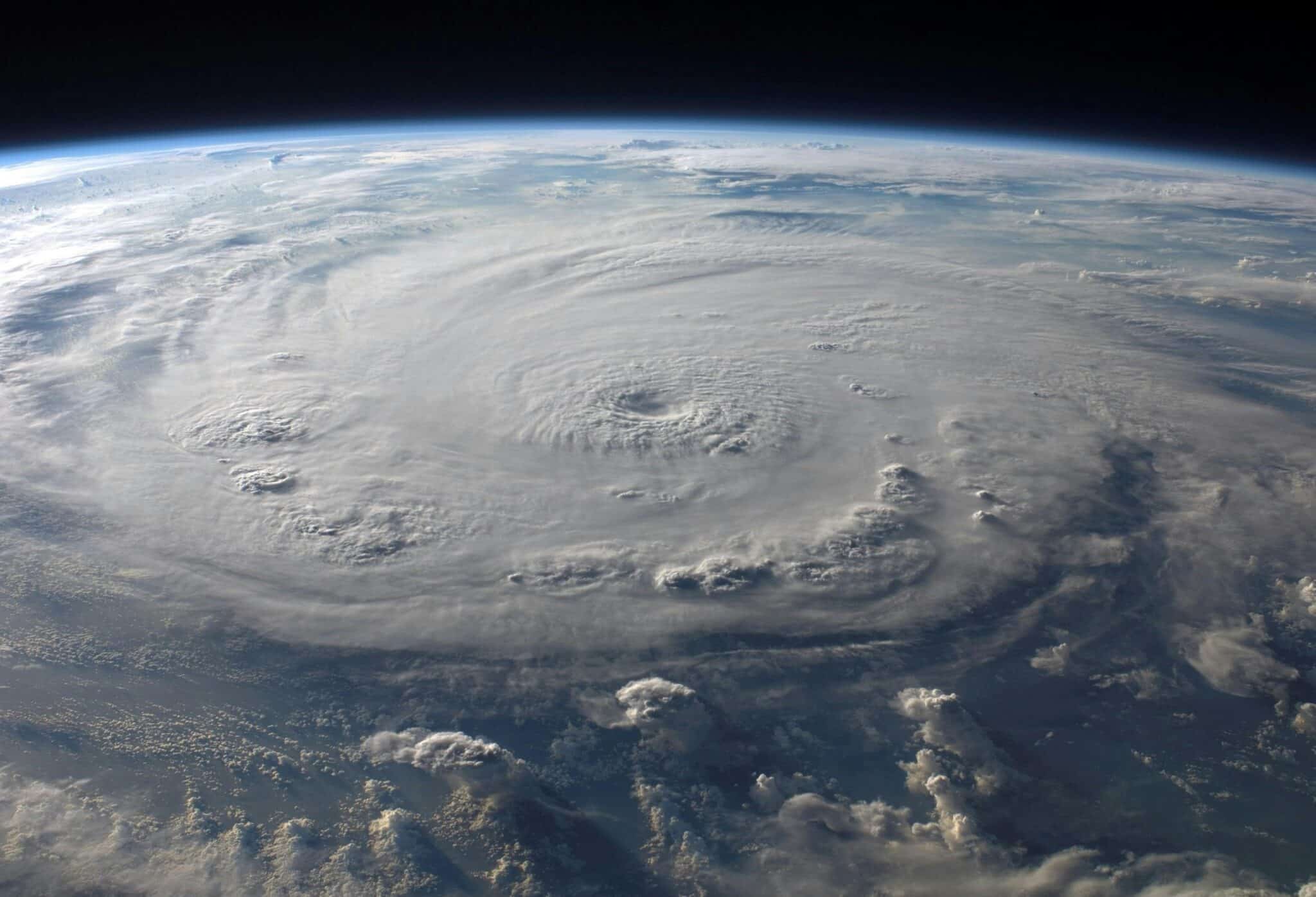
The Science Behind Hurricane Formation 🌀
Understanding how hurricanes develop helps you interpret the information your tracking app provides. These massive storm systems require specific conditions to form and intensify, which is why they only develop in certain regions and seasons.
Warm ocean water above 80°F (27°C) provides the energy source—heat and moisture evaporating from the sea surface fuel the storm’s engine. Low wind shear (minimal change in wind speed or direction with altitude) allows the system to organize vertically without being torn apart.
Initial disturbances often come from tropical waves moving westward off the African coast. When conditions align, these disturbances develop closed circulation patterns, first becoming tropical depressions, then tropical storms, and finally hurricanes when sustained winds reach 74 mph.
Your app tracks these developmental stages, showing when systems intensify or weaken based on changing ocean temperatures, atmospheric moisture, and wind patterns. This information helps forecast models predict whether a tropical disturbance will fizzle out or strengthen into a dangerous hurricane.
Beyond Hurricanes: Tracking Severe Thunderstorms and Tornadoes
While hurricanes generate dramatic headlines, severe thunderstorms and tornadoes cause significant damage across broader geographic areas. Quality storm apps provide equal attention to these rapid-onset threats that can develop with minimal warning.
Severe thunderstorm watches indicate conditions favorable for storms producing large hail, damaging winds, or tornadoes. Warnings mean severe weather has been detected and you should take shelter immediately. Your app should clearly distinguish between watches and warnings with different notification styles.
Tornado warnings deserve special attention—these indicate radar has detected rotation or a tornado has been spotted. Some advanced apps display storm-based warnings showing the specific thunderstorm cell generating the threat and its projected path, rather than just county-wide alerts.
The Role of Artificial Intelligence in Weather Prediction 🤖
Machine learning algorithms are revolutionizing weather forecasting, and their innovations are appearing in consumer storm tracking apps. AI systems analyze decades of historical weather data to identify patterns that precede severe weather events, often detecting subtle signals that traditional models miss.
Neural networks trained on radar imagery can identify developing rotation within thunderstorms earlier than conventional detection methods, potentially providing extra warning time before tornadoes form. Computer vision algorithms automatically identify cloud features in satellite imagery that indicate strengthening or weakening hurricanes.
Some apps now incorporate AI-powered nowcasting—ultra-short-range forecasts covering the next few hours. These systems track individual storm cells and predict their movement, intensity changes, and precipitation rates with impressive accuracy, particularly valuable during rapidly evolving severe weather situations.
Privacy and Data Usage Considerations
Weather apps require location access to provide relevant local forecasts and warnings, but this raises legitimate privacy questions. Reputable applications should clearly explain how they use location data and offer granular privacy controls.
Check whether apps access your location continuously or only when actively in use. Continuous tracking drains battery life and may not be necessary if you primarily need forecasts for a fixed home location rather than tracking your movements.
Review the app’s data sharing policies—some free weather services monetize user data by sharing location patterns with advertisers. Premium paid versions often eliminate this data sharing while removing advertisements, making them worthwhile investments for privacy-conscious users.
Staying Connected When Storms Knock Out Infrastructure 📡
Severe weather often damages cellular towers and electrical infrastructure, potentially cutting off your access to weather apps exactly when you need them most. Smart preparation includes offline contingencies.
Some weather apps offer downloadable radar regions that work without internet connectivity, displaying the last-received data and warnings. NOAA Weather Radio provides official alerts through dedicated receivers that operate independently of cellular networks.
Battery-powered or hand-crank emergency radios ensure you can receive weather information even during extended power outages. Consider mobile battery packs that can recharge your phone multiple times, keeping your storm tracking apps operational throughout multi-day events.
Teaching Children About Storm Safety Through Apps 👨👩👧👦
Weather apps provide excellent educational opportunities for teaching children about meteorology and emergency preparedness. Interactive radar displays and animated storm tracks make abstract concepts tangible and engaging for young minds.
Use approaching storms as teaching moments to explain how meteorologists predict weather, what different warnings mean, and why preparation matters. Involve children in emergency planning by letting them help gather supplies, identify safe rooms, and practice shelter drills.
This education builds weather awareness and reduces anxiety by replacing fear with understanding. Children who understand why storms form and how forecasting works often feel more empowered than those kept in the dark about approaching weather threats.
The Future of Storm Prediction Technology 🔮
Meteorological technology continues advancing rapidly, promising even more accurate and earlier warnings in coming years. Next-generation weather satellites with enhanced resolution and faster refresh rates will provide more detailed views of developing storms.
Phased array radar systems that scan the entire sky in seconds rather than minutes will revolutionize tornado warning lead times. As these technologies mature, consumer apps will inherit their benefits, translating cutting-edge science into accessible smartphone interfaces.
Improved climate models will help forecasters better predict seasonal hurricane activity months in advance, allowing communities to prepare resources and evacuation plans well before storm season peaks. Your weather app will increasingly serve not just as a short-term warning system but as a long-range planning tool.
Making Weather Apps Part of Your Emergency Preparedness Plan
The most sophisticated storm tracking app provides little value if you don’t integrate it into a comprehensive emergency strategy. Establish clear protocols for what actions you’ll take when your app issues different warning types.
Discuss your weather app’s features with family members so everyone understands how to interpret alerts and access critical information. Identify which household member will monitor forecasts during threatening weather and communicate updates to others.
Test your notification settings regularly to ensure alerts are reaching you reliably. Periodically review and update your emergency supply kit, evacuation routes, and communication plans so you’re always prepared when your storm app delivers that critical warning.
In our increasingly connected world, storm and hurricane prediction apps represent a perfect fusion of advanced science and practical utility. These powerful tools place professional-grade meteorological information directly in your hands, transforming your smartphone into a personal weather station and early warning system. By understanding how to choose, interpret, and act on the information these apps provide, you’re taking responsible steps to protect yourself, your loved ones, and your property from nature’s most powerful atmospheric phenomena. Stay informed, stay prepared, and let technology be your guide through whatever storms may come. 🌈